Hidden River
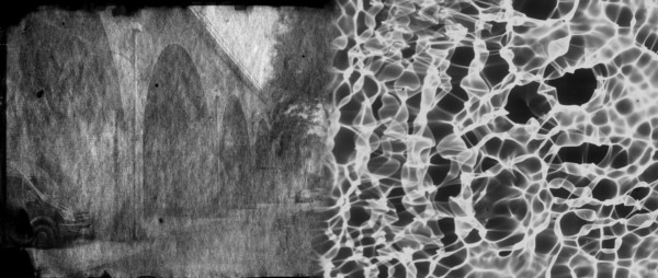
Once crucial to the growth and industry of the medieval city of Coventry, the River Sherbourne is an underused and overlooked resource. This project intends to cast light into the Sherbourne and consider the importance of water within the urban environment. Photographs have been made using historic and wet analogue processes to create images and prints of the flow patterns and the environment around where the river disappears from view.
We are inviting residents to participate with the project by making photographs that show their use of the natural environment around the Sherbourne. The importance of this area as a breathing space to the inhabitants of the city, particularly during a pandemic is of particular interest.
Please share images of the River Sherbourne and how you use it with us on Twitter and Instagram using the hastag #hiddenrivercov.
The River:
The River Sherbourne flows for around 8 miles through Coventry, originating in a pleasingly round pool within a field near Hawkes End, Allesley. It bubbles airily through suburbia, before heading into shadows, moving darkly into the city behind industrial arches. Disappearing from view beneath heavy gates overlooked by high rise flats in Spon End, it sluggishly sinks under the concrete ringroad through clogged metal teeth. Culverted beneath the city centre, with only small, neglected flashes of light into the tunnel, briefly glimpsed shimmering above murk behind shop bins on The Burgess. Emerging again to stream into daylight, restored after passing back under the concrete ringroad, the water runs away from the city into the Sowe near Stivichall.
The Project:
This initial trial project was funded by City of Culture 'Coventry Creates' commissions in partnership with Centre for Cultural & Media Policy Studies, Warwick and the Centre for Agroecology, Water and Resilience, Coventry University